Researchers at the University of Minnesota Twin Cities have developed aerial robots equipped with artificial intelligence (AI) to detect, track and analyze wildfire smoke plumes. This innovation could lead to more accurate computer models that will improve air quality predictions for a wide range of pollutants.
According to a 2024 Associated Press report, 43 wildfires resulted from 50,000 prescribed burns between 2012 and 2021, creating the need for better smoke management tools.
Previous simulation tools have worked to model fire and smoke particle behavior, but there were still limitations in accurate collection of data, modeling and the current field tools to observe these smoke plumes. In this paper, the researchers addressed the challenges in accurately modeling how smoke particles behave and spread during wildfires and prescribed burns.
Jiarong Hong, a professor in the University of Minnesota’s Department of Mechanical Engineering, said, “A key step is understanding the composition of smoke particles and how they disperse. Smaller particles can travel farther and stay suspended longer, impacting regions far from the original fire.”
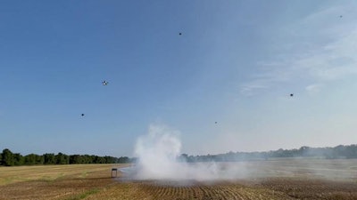
Using a swarm of AI-guided aerial robots, they were able to capture multiple angles of the smoke plumes to create 3D reconstructions of smoke plumes and analyze flow patterns. Unlike traditional drones, these aerial robots can identify smoke and navigate into it to collect data.
Nikil Nrishnakumar, a graduate research assistant with the Minnesota Robotics Institute at the University of Minnesota, said, “This approach allows for high-resolution data collection across large areas—at a lower cost than satellite-based tools. It provides critical data for improving simulations and informing hazard response.”
The cost-effective technology has potential beyond wildfires and could be adapted for sandstorms, volcanic eruptions, and other airborne hazards. The team’s next goal is to translate the research into practical tools for early fire detection and mitigation.
“Early identification is key,” Hong said. “The sooner you can see the fire, the faster you can respond.”
Previously, the team developed an autonomous drone system, equipped with onboard computer vision and sensors to detect and track wildfire smoke plumes in real time. Building on this, they will now be focusing on efficient plume tracking and particle characterization using Digital Inline Holography with coordinated multi-drone systems. They are also working on integrating a type of drone, called a fixed-wing VTOL (Vertical Takeoff and Landing), that can take off without a runway and can fly for more than an hour for extended-range surveillance missions.